By Rich House (September 2017)
A new "Outline application for 94 dwellings with access" has been submitted for "Land West Of Cupernham Lane Romsey Hampshire".
This article looks at the plans from a Romsey cyclist's perspective. I have gone through current the planning documents pulling out bits relevant to cyclists. Hopefully we can collectively review them and put forward suggestions to shape the plans so they are better for Romsey cyclists. As money is short new developments offer our best opportunity to improve cycle provision in Romsey as this can be bundled in as a condition of development.
This article looks at the plans from a Romsey cyclist's perspective. I have gone through current the planning documents pulling out bits relevant to cyclists. Hopefully we can collectively review them and put forward suggestions to shape the plans so they are better for Romsey cyclists. As money is short new developments offer our best opportunity to improve cycle provision in Romsey as this can be bundled in as a condition of development.
The documents I've included extracts from come from TVBC Planning Application 17/02183/OUTs. It proposal is just at outline planning stage as yet. It would be great if cyclists could send comments directly to TVBC (they have a comment button on their page). We of course also welcome your thoughts at Romsey Cycle Hub.
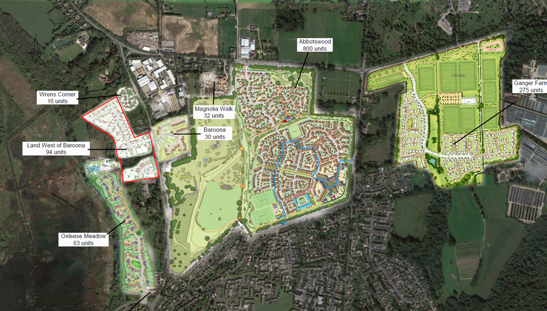
21 Aug 2017 - Drawing - AERIAL OVERVIEW
I've cut out the relevant bit of this below. The planned development is shown bounded by red lines. Here it is referred to as "Land West of Baroona" rather than "Land West of Cupernham Lane". Possible Cycle access South through Oxlease Meadow to Fishlake Medows is mentioned in other documents, but is not clear how this is connected to from this and other planning application's maps.
21 Aug 2017 - Supporting Information - TRANSPORT ASSESSMENT
The development should encourage cycling ....
2.0 TRANSPORT POLICY SUMMARY
[ ...]
2.7 The Test Valley Borough Council (TVBC) Revised Local Plan (2011-2029) was adopted in January 2016.
2.8 Objective 13, relates to transport and states that TVBC sets out to 'encourage use of public transport, cycling and walking networks to help reduce reliance on cars and provide choice'."
2.9 The key transport policy relating to this development proposal is Policy T1: Managing Movement, which states ‘Development will be permitted provided that:
a) its location is connected with existing and proposed pedestrian, cycle and public transport links to key destinations and networks; and
b) measures are in place to minimise its impact on the highway and rights of way network and pedestrian, cycle or public transport users; and
c) the internal layout, access and highway network is safe, attractive, in character, functional and accessible for all users and does not discourage existing and proposed users; and
d) it does not have an adverse impact on the function, safety and character of and accessibility to the local or strategic highway network or rights of way network; and
e) Provision is made to support and promote the use of sustainable transport, including the submission of a site travel plan where appropriate.’
Existing cycling provision relevant to the development is summarised. However all is not as good as it is seems - follow the buttons or hyperlinks for key clarifications by Romsey Cycle Hub as to how good cycle routes are. Should the developers be asked to fund improvements to these?
"3.0 EXISTING CONDITIONS
[...]
Walking and Cycling
3.10 On Cupernham Lane, to the north of the roundabout junction with Fishlake Meadows there are only footways for c.100m north used for access to residential dwellings. North of this point there are no definitive footways on Cupernham Lane as it becomes a typical country lane, with verges and hedgerows either side of the carriageway. The extent of footway does however connect to the footpath network being provided as part of the Abbotswood development, refer to the plan in Appendix A.
3.11 As part of the approved Baroona development there will be footways provided either side of the site access from the eastern side of Cupernham Lane and a pedestrian network through the residential development. There will also be a footpath connection from the eastern side of the Baroona site to the western side of the Abbotswood development, where further pedestrian facilities provide safe access to the local centre.
3.12 South of the roundabout there are footways on both sides of Cupernham Lane through the residential area. This provides good accessibility to the local facilities in Romsey.
3.13 There is a circa 2.0m wide footway on the southern side of the Fishlake Meadows, with no footway on the northern side. This footway runs the length of Fishlake Meadows providing connection to the A3057 Greatbridge Road to the west, to Cupernham Lane to the east and to the footways within the residential area to the south of Fishlake Meadows.
3.14 As part of the approved development for Oxlease Farm [...], an emergency access / shared footway / cycleway will be provided connecting both developments [see drawing]. This link will be retained whilst footways are to be provided along the extents of the spine road of Oxlease Farm as such providing a footway connection to Fishlake Meadows from the proposed development. There is an existing cycleway that starts c.170m south of the Cupernham Lane / Fishlake Meadows roundabout and connects to both Romsey railway station and the town centre, as well as on to Romsey Sports Centre, refer to Figure 3 and Appendix B. This cycle route has part of its path alongside the canal. It is also part of the National Cycle Network’s Route 24 which also continues northwards past the site along Cupernham Lane as an on-road signed route.
3.16 There is another key cycle route between Fishlake Meadows and Romsey School [ .. ] These two cycle routes and the proposals associated with Oxlease Farm give good cycle accessibility from the site to key destinations within Romsey, thus making local travel by cycle safe and feasible."
It will look to retain the cycleway connection to Oxlease Farm. This sounds like it may provide access through to the Fishlake Meadows & canal cycle paths, but its a bit woolly sounding. Cycle spaces will be provided for the new dwellings.
"4.0 PROPOSED DEVELOPMENT AND SITE ACCESS LAYOUT
[ ...]
4.4 The primary site access will look to retain the emergency / shared footway / cycleway connection to the consented Oxlease Farm development to the south. This will enhance the sustainable connectivity of the proposed development by providing a safe link with low traffic flows and slow vehicle speeds to Fishlake Meadows
[...]
4.11 All on-site car and cycle parking will be provided in accordance with the minimum residential parking standards set out in TVBC Revised Local Plan Annex G – Parking Standards (T2); as set out below:
• 1-bedroom houses
o 1 vehicle spaces per dwelling;
o 1 cycle space per dwelling;
• 2 - 3-bedroom houses
o 2 vehicle spaces per dwelling;
o 2 cycle space per dwelling;
• 4+ bedroom houses
o 3 vehicle spaces per dwelling;
o 2 cycle space per dwelling;"
21 Aug 2017 - Supporting Information - RESIDENTIAL TRAVEL PLAN
Pedestrians will have internal footpaths, but cyclists will use the roads. Residential properties will have cycle storage.
"1.1.3 Over the course of the planning and design process, following this outline application stage, the
site will be carefully planned so that:
• The footway network through the site will allow safe pedestrian access to provide a high level of pedestrian accessibility;
• The internal road network within the site will allow safe passage for cyclists; and
• All residential properties have sufficient space for cycle storage facilities."
There will be cycle access South to Fishlake Meadows, though this appears to be mainly via the Oxlease Farm Development roads. Pedestrians will be able to cross over the canal to the towpath - should cyclists be able to do this as well to link to the forthcoming towpath cycle path extension north?
2.2.2 The proposed site has permeable access throughout and provides pedestrian, cycle and vehicular connection east to Cupernham Lane, together with further pedestrian and cycle access south to Fishlake Meadows, and pedestrian access west over the canal to the towpath and Fishlake Meadows.
Should the internal footpaths be widened and made into shared cycle/pedestrian paths?
2.3 Travel on Foot or Cycle
2.3.1 Walking and cycling offers the cheapest, healthiest and most convenient way to travel over short distances. It is considered that walking is attractive at distances up to 2km (1.25 miles) and cycling up to 5km (3.13 miles).
2.3.2 Within the site the following pedestrian and cycle facilities will be provided to attract new residents to use these sustainable modes of travel:
• The footway network through the site will allow safe pedestrian movement, with 2.0m wide footways and sections of shared surfaces within a 'home zone' environment to provide a high standard of pedestrian accessibility;
• The internal road network within the site will allow safe passage for cyclists; and
• All residential properties have sufficient space for cycle storage facilities.
2.3.3 There is an existing cycleway that starts c.170m south of the Cupernham Lane / Fishlake Meadows roundabout and connects to both Romsey railway station and the town centre, as well as on to Romsey Sports Centre, refer to Figure 3 and Appendix B. This cycle route has part of its path alongside the canal. It is also part of the National Cycle Network’s Route 24 which also continues northwards past the site along Cupernham Lane as an on-road signed route.
2.3.4 There is another key cycle route between Fishlake Meadows and Romsey School, as also shown on Figure 3 [Key cycle route between Fishlake Meadows and Romsey School]. These two cycle routes give good cycle accessibility from close to the site, via the Oxlease Farm development, to key destinations within Romsey, thus making local travel by cycle safe and feasible.
[...]
2.4.6 Romsey railway station is located c.1.5km (20-minutes) south of the site and it can be accessed by foot or cycle via the previously discussed routes."
2.5 Key Travel Destinations Within Romsey
2.5.1 There are several day-to-day local facilities that can be accessed from the site by sustainable modes of travel; walking, cycling or public transport"
21 Aug 2017 - Supporting Information - PLANNING, DESIGN AND ACCESS STATEMENT
Houses will have garages & cycle storage sheds for storing cycles. Apartments will have communal cycle stores. Will the storage sheds be easy to access?
"On the southern edge of the site is a footpath approved as a pedestrian/cycle access between Cupernham Lane and the approved Oxlease Farm development."
"Cycle parking is provided for houses in the form of garages and cycle storages sheds whilst the proposed apartments will be catered for through the provision of secure communal cycle stores."
"The illustrative proposals for the southern parcel includes the provision of three flatted blocks arranged in a crescent and each containing ten 2-bedroom units. [..] Access to this part of the site is via a simple priority junction in the location of the existing field gate. A short access way leads to a landscaped parking courtyard that has been designed to accentuate the crescent arrangement of the flats. Visitor parking spaces are located close to the entrance of the site, while cycle and bin storage is provided in dedicated communal structures located conveniently for future occupiers and refuse tender operatives."
"A potential footpath connection could be made to the Oxlease Farm pedestrian/cycle route to maximise the connectivity between developments currently being built and the wider area."
1 Sep 2017 - Consultation Responses - HIGHWAYS (TVBC)
Test Valley Borough Council say inadequate facilities have been proposed for pedestrians & cyclists going to and from the site ...
"Are the access (including visibility requirements) and manoeuvring arrangements acceptable? No
Please give reasons:
[ ... ]
A further impact on the access design is the need for an island to be provided in the centre of Cupernham Lane to enable pedestrians and cyclists to cross Cupernham Lane.
The Safety Audit contents are noted, but in view of the alternative route for pedestrians from the southern area travelling north being relatively inconvenient a further route from the eastern end of the car park north to the northern access is required through the area of Open Space between them. The vertical alignment of which must be DDA compliant. Secondly a pedestrian/cycle link is required from the southern end of the same car park to link on to the “Bellway Homes Footpath Access”."
"Amendments to the scheme are likely to overcome the following reasons for refusal.
Conditions/Reasons for refusal including policy references:
[... ].
Inadequate facilities have been proposed for pedestrians and cyclists going to and from the site."
4 Sep 2017 - Public Comment - MRS MARILYN THWAITES(FULL)
A new pavement will be built on the opposite side of Cupernham Lane. This is to be done as part of the Baroona development over the road. Will this be just for pedestrians? How will people cross the road?
"There is no public transport in Cupernham Lane north of Woodley Lane. The nearest bus stop is at least 0.5miles away being Chivers Road at Abbotswood away and Romsey station is 1 mile away. The new pavement to be built serving the Baroona development will be on the wrong side of
the road for this development encouraging pedestrians to cross the busy Cupernham Lane."
