What's Planned for Cyclists at Ganger Farm (Now called Kings Chase)
By Rich House (April 2017)
In July last year permission was given for the development of 275 dwellings and sports facilities at Ganger Farm. The aims of the plan include:
"Promoting walking and cycling to minimise travel by private car" DESIGN AND ACCESS STATEMENT PT 2
This article looks at the plans with a cyclist's hat on to see if they fulfill this. Hopefully we can shape it so it is even better for cyclists. Although the consultation period for this application has ended we may still be able to influence the fine details of the implementation.
I have gone through many of the planning documents pulling out bits relevant to cyclists. There are hundreds of them so I have only read the most likely sounding ones. For future planning applications it would be great to have a single document that pulls together all the information relevant to cyclists.
The documents I've included below have been sourced from TVBC Planning Applications Online. To see them search for application 14/01090/FULLS. Click on the documents tab. The links below appear to result in "Document Unavailable" if the Documents are not first loaded this way.
Planning Maps
I have selected some of the most informative planning maps below. Click on them and then on the button in the top right corner to view them larger. They appear to contain paths, but which are cycle paths is not 100% clear from the diagram alone. I have included a section below called Cycle Paths which has a little more detail where I have found it. It would be good to find out ore about the surface type, sharing type, signage and junctions. If anyone finds more detail it would be great to hear from you.
Overall Site
West Residential Area in More Detail
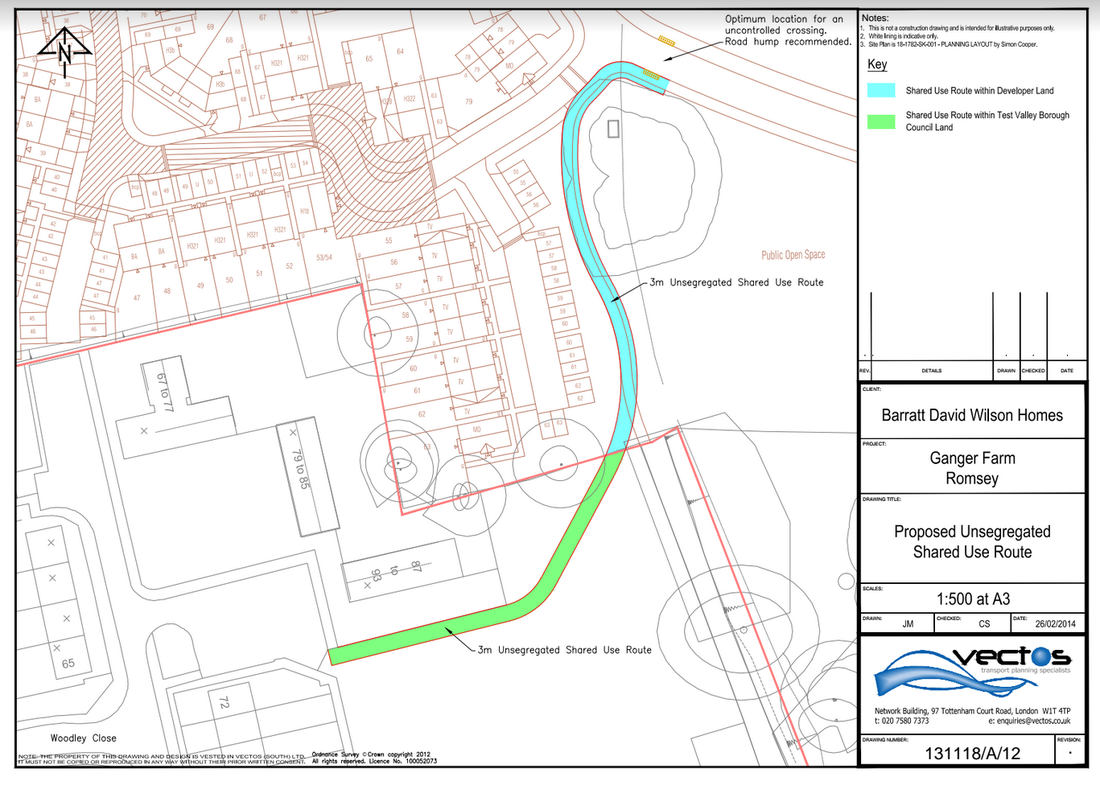
The path running south beside the balancing pond and terminated by the red boundary line is to be a shared use path. It will continue to Woodley Close across TVBC land. TRANSPORT ASSESSMENT PG 139-150
The path running south beside the balancing pond and terminated by the red boundary line is to be a shared use path. It will continue to Woodley Close across TVBC land. TRANSPORT ASSESSMENT PG 139-150
Southern Residential Area in More Detail
Cycle Storage Buildings
"Each dwelling is provided with appropriate space for secure cycle storage to facilitate sustainable modes of travel. This is provided within garages (which are designed to meet the 6m x 3m standard to enable car and cycle parking), sheds within the rear garden of plots without garages with rear access to enable convenient access and communal cycle sheds for flats." - DESIGN AND ACCESS STATEMENT PT 2
|
Bin / Cycle Store (flats)
|
|
It is as yet a little unclear what type of rack is being used in the Cycle Stores. Does anyone know?
Sheds are to be located near access points to properties. Are these conveniently sized for cycles?
The garage plans don't include any specifics on their support for cycle storage so I've not sown them above.
Sheds are to be located near access points to properties. Are these conveniently sized for cycles?
The garage plans don't include any specifics on their support for cycle storage so I've not sown them above.
"The residential units will have an average of 2 cycle parking spaces per unit, inclusive of visitor parking." TRANSPORT ASSESSMENT PG 1-77
Cycle Parking
It's good to see that planning policy stipulates good cycle parking in new developments and that the plan is to meet these.
However there doesn't appear to be any cycle parking near the play area. Play areas often have railings to hitch cycles to. However would be good to encourage kids to start seeing cycling as normal transport with normal parking.
"Cycle parking is proposed in accordance with the Council’s standards to meet the needs of users of the sports facility and enable/promote access by sustainable modes." DESIGN AND ACCESS STATEMENT PT 2
"Proposed Development Parking Provision: Sports Facilities :" TRANSPORT ASSESSMENT PG 1-77
Description |
Long Stay Standard |
Long Stay Provision |
Short Stay Standard |
Short Stay Provision |
Main Car Park |
1 space/6 staff or 1 space/5 pitches |
2 spaces |
1 stand per ha pitches |
6 spaces (based on 5.2 hectares of pitches) |
Overflow |
- |
2 |
- |
- |
"A total of eight cycle parking spaces in the form of four Sheffield stands will be provided associated with the sports pavilion" TRANSPORT ASSESSMENT PG 1-77
Sports Pavilion
"A number of cycle parking spaces will be made available on the site. Showers and changing |
"Cycling will be promoted by the management of the Sports Pavilion as an alternative to the |
"A dedicated travel notice board will be installed. This will include all relevant public
transport, walking, and cycling information but also details of the Travel Plan itself" TRANSPORT ASSESSMENT PG 651-692
Cycle Paths
The council policy is that new developments connect to existing cycle paths ...
"Policy T1 outlines that development will be permitted provided that its location is connected with existing and proposed pedestrian, cycle and public transport links to key destinations and networks, measures are in place to minimise its impacts on highway network, pedestrian, cycle or public transport users and the internal layout, access and highways network is safe, attractive, in character, functional and accessible for all users and does not discourage existing and proposed users." DESIGN AND ACCESS STATEMENT PT 1
Finding information about cycle paths from the plans has been very difficult. From what I can deduce from what I've read there is only one definite cycle path within the development site: a shared use path from South West of Site to Woodley Close.
There are also some cycle paths and access mentioned in vague terms. I am as yet unclear what these are and which if any are being implemented. If anyone could shed some light on these it would be great.
- Circular Path
- Track serving Ganger Farm
- Ganger Farm Lane
- Jermyns Lane Access
The Layout maps above also suggest there are many more paths, but it is unclear what transport methods these support.
Cycle Path from South West of Site to Woodley Close
There will be a 3m wide shared pedestrian & cycle use path between Woodley Close and the South West of the new site.
"Cyclists will be able to use the shared footway/cycleway network that will link through the site including the direct 3m footpath/cycleway link between Braishfield Road and the site" TRANSPORT ASSESSMENT PG 1-77 # |
Pedestrian and cycle access is also proposed [..] to the south west, towards Woodley Close to enable improved connectivity to the wider area and encourage sustainable modes of travel." DESIGN AND ACCESS STATEMENT PT 2 |
Will cyclists and pedestrians living in the Western residential area first need to head East or South East to this path before heading back West and on to town? Or can they access Woodley Close more directly via a connecting road?
Woodley Close connects to an existing shared use path along Braishfield Rd to Abbotswood. However it is unlikely that cyclists heading to the town centre would double back to Abbotswood. Instead they are more likely to head down Woodley Lane, which is as yet a little trickier to get to safely on a bike. With the increase in car traffic from Abbotswood the Woodley Lane / Brashfield Rd / Ganger Farm Rd cross roads is now quite dangerous and I believe an accident has already occurred here.
"The Council identified some traffic issues on Braishfield Road that will be tackled through the mitigation measures of the Abbotswood scheme. These include [..] improved pedestrian and cycle links between Abbotswood and local services and facilities (including footways on Braishfield Road), including a link to the entrance of Sir Harold Hillier Gardens (on Jermyns Lane, accessed from Braishfield Road)". TRANSPORT ASSESSMENT PG 1-77
Possible Path - Circular Path
"We are pleased to see the circular path will now be installed as a tarmac surface; this is a much more sustainable surface and allows bikes, prams, scooters etc to use the path safely." 14_01090_FULLS-COMMUNITY_AND_LEISURE-1016562.rtf
Possible Path - Track serving Ganger Farm
" The existing access track serving Ganger Farm will be retained in its current configuration and will provide pedestrian, cycle and emergency access. This track will also provide access to the proposed overflow car park in the north eastern corner of the site. A new pedestrian access is proposed from the northern boundary to link with Sir Harold Hillier Gardens and Arboretum, to enable dual usage of the overflow car park." DESIGN AND ACCESS STATEMENT PT 2
Possible Path - Ganger Farm Lane
"The Council specifies that the Proposed Development should have ‘vehicular access from Jermyns Lane and pedestrian and cycle access from Ganger Farm Lane'" TRANSPORT ASSESSMENT PG 1-77
Possible Path - Jermyns Lane Cycle Access
"The principal site access is proposed from the north, off Jermyns Lane, with a new priority junction, providing vehicular, pedestrian and cycle access, with a well-defined central street through the site connecting the sports facilities and residential development parcels." DESIGN AND ACCESS STATEMENT PT 2 |
"The principal site access is proposed from the north, off Jermyns Lane, with a new priority junction, providing vehicular, pedestrian and cycle access, with a well-defined central street through the site connecting the sports facilities and residential development parcels." DESIGN AND ACCESS STATEMENT PT 2 |
"The Council specifies that the Proposed Development should have ‘vehicular access from Jermyns Lane and pedestrian and cycle access from Ganger Farm Lane'" TRANSPORT ASSESSMENT PG 1-77
School Routes
There is an assessment of walk to School routes in the plans (see TRANSPORT ASSESSMENT PG 646-650) . This is great, however shouldn't there also be an similar assessment for cycling to school?
Shared Surfacing
"The residential zones within the Proposed Development will have shared surfacing giving pedestrians and cyclists’ priority of movement. Horizontal traffic calming, such as build outs and designing out long, straight sections of road will be applied within the residential zones to ensure". TRANSPORT ASSESSMENT PG 1-77 |
"The use of shared surface treatment will be incorporated into the design so that pedestrians and cyclists retain priority of movement in the areas where residents are concentrated. The residential blocks will be permeable to provide safe and easy walking and cycling routes to enable ease of access". TRANSPORT ASSESSMENT PG 1-77 |
Cycle Safety
The plans include detailed local accident data analysis. I have not had time to through this. It is in TRANSPORT ASSESSMENT PG 78-136 if anyone has more time.
"Of the five accidents involving cyclists, three occurred at various junctions with Braishfield Road (Woodley Lane, Sandy Lane or Winterbourne Road)." TRANSPORT ASSESSMENT PG 1-77
What measures are being taken to mitigate further accidents at these junctions?
Cycle Vouchers or Discounts
There is the possibility of cycle vouchers or discounts for new residents...
"Cycle parking will be provided in line with local parking standards at the site. The developer will also hold negotiations with local cycle equipment retailers with a view to establishing whether time-limited discounts can be offered to residents of the proposed development at
first occupation. It is noted that the outcome of such a measure is dependent on agreement between the developer and the retailer." VECTOS RESPONSE ON HIGHWAY OFFICERS COMMENTS
"The provision of cycle vouchers or discounts will be dependent on the outcome of negotiations with local cycle retailers as noted above." VECTOS RESPONSE ON HIGHWAY OFFICERS COMMENTS |
"There should be a stronger commitment to this measure within the RTP, with each household receiving either a bus taster voucher or cycle voucher within the welcome pack. " VECTOS RESPONSE ON HIGHWAY OFFICERS COMMENTS |
